

MAJOR SNOW STORM EXPECTED TUESDAY - WEDNESDAY
Feb 16
2 min read
38
5362
2

FEBRUARY 16, 2025 -- A MAJOR WINTER STORM is expected to impact all of Southern Illinois between Tuesday and Wednesday.
A band of light snow may move into the I-64 corridor as early as Tuesday morning. During the day Tuesday, we may see 1-2", but this is just a precursor to the main event.
*** MORE DETAILED INFORMATION BELOW THE PICTURES ***


Further south, mainly Route 13 and southward, the main snow will begin moving in later Tuesday afternoon and into early Tuesday evening. Once the snow arrives, it will become heavy rapidly with travel conditions deteriorating quickly Tuesday evening. For areas along and south of Route 13, I would recommend getting where you need to be BEFORE 5 p.m. on Tuesday.
A strong breeze from the north will be blowing the dry, fluffy snow around Tuesday night, leading to low visibility and near whiteout conditions at times. This will create snow drifts in some locations and also cause more challenges with clearing roads as snow blows back over roadways after plows go through.
Snow to liquid ratios will be much higher than a typical due to temperatures being in the lower 20s. While typically, 1" of liquid roughly equates to 10" of snow... This time around, ratios might be as high as 1" of liquid equating to 20" of snowfall. Right now, I'm expecting 0.40" to 0.60" of liquid equivalent with this storm, so it's easy to see where substantial snow is expected.
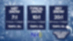
Through Wednesday morning, I'm expecting 4-8" of snowfall to occur along the I-64 corridor, basically along and north of a line from Pinckneyville to Benton to McLeansboro. Further south, I'm expecting 6-10" of snowfall with isolated amounts approaching 12". Let be honest, impacts are the same in Southern Illinois once snowfall amounts start getting over 4". Travel will be difficult Tuesday night and into Wednesday. Closures, including schools, are likely Wednesday and potentially the remainder of the week.
In addition to the snow, DANGEROUSLY COLD weather will settle in through the second half of the week. The coldest morning may end up being Thursday as clearing skies and thick snowpack aid in maximizing the temperature drop. Temperatures near ZERO are possible with wind chills 10-15-degrees BELOW ZERO.

Afternoon high temperatures Thursday afternoon will only be in the 10s. It will be several days before temperatures finally climb above freezing. In other words, snow will be around for a little while.
There is still uncertainty regarding the exact placement of the heaviest snow in Southern Illinois. We're still TWO DAYS away from this storm, so some changes to the forecast remain possible. Stay tuned!


This all looks pretty brutal . I'm happy to have the information though
I wonder when was the last time we had this much snow!